Rulers: United States
Minor outlying islands
This record comprises the U.S. territories without a permanent civilian population (which for statistical purposes have been actually grouped under the name United States Minor Outlying Islands), except the separately treated Wake Island. Those include Howland and Baker Islands, Jarvis Island, Johnston Atoll, Kingman Reef, Midway Islands, and Palmyra Atoll, all in the Pacific, plus Navassa Island, in the Caribbean. Related to most of these is the Guano Islands Act passed by the U.S. on Aug. 18, 1856, providing that "when any citizen or citizens of the United States may have discovered, or shall hereafter discover, a deposit of guano on any island, rock, or key not within the lawful jurisdiction of any other government, and not occupied by the citizens of any other government, and shall take peaceable possession thereof, and occupy the same, said island, rock, or key may, at the discretion of the President of the United States, be considered as appertaining to the United States."
See also Wake Island for the national monument including the islands in this record except Midway and Navassa.
Howland and Baker Islands
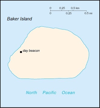
1818: Baker Island is discovered by Captain Elisha Folger of the Nantucket ship Equator and is given the name New Nantucket.
1822: Several U.S. whaling ships sight and chart Howland Island (56 km north of Baker), including the Oeno commanded by George B. Worth, who names it Worth Island.
August 1825: Captain Obed Starbuck of the whaler Loper sights Baker Island, and the name Loper Island comes to be used alongside New Nantucket.
Dec. 1, 1828: Captain Daniel McKenzie lands on Howland Island aboard the whaler Minerva Smyth and names it for the ship's owners (Isaac Howland, Jr., and Gideon Howland). It is placed on charts under the name Howland Island. McKenzie had given the same name to an island he thought he discovered in 1826, which however was likely the already-discovered Vostok Island (in modern Kiribati); he probably learned that it was not a discovery and retracted the name for later use.
1832: The captain of U.S. whaling ship Gideon Howland, Michael Baker, sights Baker Island, which ultimately comes to be named after him. He returns on Aug. 14, 1839, raises an American flag, and claims it for the United States. While digging a gravesite for a dead seaman, he discovers guano deposits.
Sept. 9, 1842: The U.S. whaling vessel Isabella, Captain George E. Netcher, sights Howland Island. As Netcher finds it unmarked on his chart, he supposedly names it again Howland Island, after the lookout who spotted it - a curious coincidence if true. Though uninviting, with no natural anchorages and overrun with rats from an old shipwreck, the guano deposits, when analyzed, are richer than those on either Baker or Jarvis.
Sept. 1, 1855: Baker sells his interest in Baker Island to a group who later form the American Guano Company, which claims the island in 1856 under the Guano Islands Act and begins to mine guano there. Hawaiian guano labourers working on the island name it Puaka'ilima.
Feb. 5, 1857: Arthur Benson and Charles H. Judd take possession of Howland Island on behalf of A.G. Benson (father of Arthur) and the American Guano Company, although Arthur Benson was authorized by Netcher to take possession for Netcher's enterprise.
August 1857: Charles Henry Davis of the U.S. sloop St. Mary's surveys and makes formal claim to Baker
Island in the name of the United States.
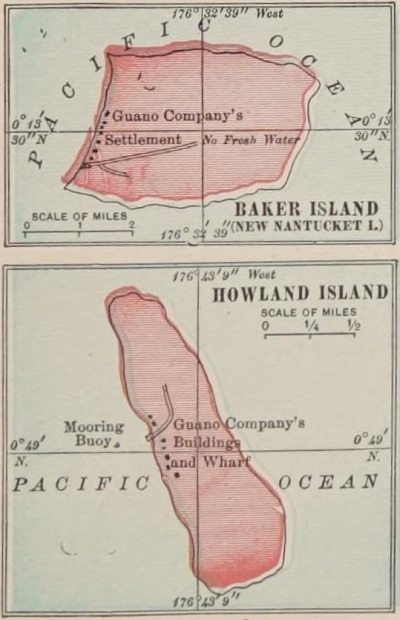
October 1858: Netcher and partners organize the United States Guano Company, and on December 3 Howland Island is legally assigned to this company. By the time the company arrives, the American Guano Company is already in full operation. A dispute ensues but is settled in court on June 11, 1865. Guano mining continues until about 1878 and again, by the British firm John T. Arundel and Co., in 1886-91. Guano labourers name the island Ulukou.
1860s: During peak guano mining at Howland Island, many ships loaded with guano wreck before they have a chance to leave the atoll. These include the Monsoon (Jan. 10, 1864), Mary Robinson (June 28, 1864), Arno (Aug. 9, 1864), Kathay (Jan. 20, 1867), and Lizzie Oakford (Sept. 28, 1868).
1880s: American guano companies abandon operations on Baker Island; however, British guano companies continue mining. John T. Arundel and Co. establishes their headquarters on the island for their guano digging enterprise in the central Pacific in 1886-91.
1910: Baker Island is abandoned as the guano supply is exhausted.
1924: The Whippoorwill expedition surveys Baker Island and finds old deep-sea moorings, remains of a pier, walls of coral stone buildings, boilers and buoys, and wooden headboards which indicate remains of a graveyard. Howland Island is found overrun by the Polynesian rat, both the brown and the black varieties.
March 30 and April 3, 1935: Camps are established on Howland and Baker respectively by men of the U.S. Army. The camp atop the western ridge of Baker Island is named Meyerton, after Capt. Harold A. Meyer. That on Howland is named Itascatown after the U.S. Coast Guard cutter Itasca.
May 13, 1936: Pres. Franklin D. Roosevelt places Howland and Baker under the jurisdiction of the secretary of the interior. An interest in developing these islands for commercial aviation stopovers, as well as in firmly establishing a U.S. presence, results in military personnel and Hawaiian employees being placed at each of the islands for several months at a time. An airstrip and a lighthouse are built on Howland as a refuelling site for the flight of Amelia Earhart, who leaves New Guinea for Howland on July 2, 1937, but is never seen again.
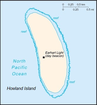
1940s: Earhart Light, near the middle of Howland's west coast, named in memory of the famed aviatrix, is partially destroyed during World War II; it is rebuilt as a day beacon during the 1960s.
1942: American civilians are evacuated after Japanese air and naval attacks in December 1941.
July 1943: U.S. troops build a new airstrip on Baker Island as a forward area defense post. In September the base is occupied and the original landing strip lengthened to permit bombers to land. The island houses 120 officers and 2,000 men.
March 1944: Considered no longer necessary to the war effort, Baker is evacuated.
June 27, 1974: The U.S. Fish and Wildlife Service is given administrative responsibility for the Howland and Baker Islands, which become national wildlife refuges.
September 2013: Kiribati and the U.S. sign a maritime boundary treaty formalizing the boundary between Baker and Jarvis Islands, Kingman Reef, and Palmyra Atoll and Kiribati's Line and Phoenix Islands.
Jarvis Island
Aug. 21, 1821: The island is first discovered from the British whaler Eliza Francis (Captain Matthew Brown) owned by three brothers Jarvis (Edward, Thomas, and William), after whom the island is named. It is for some time also called Bunker Island.
Jan. 20, 1825: The British South Seas whaler Mary, commanded by Captain Edward Reed Lacy, is lost on the island while carrying 1,800 barrels of sperm oil. The crew is rescued by two whaling ships after being stranded on the island for 6 weeks. On May 25, the ship's fittings and gear are salvaged by the New Bedford whaler Minerva Smyth.
1835: Michael Baker (see Howland and Baker Islands, above), of the whale ship Braganza, lands and claims the island for the United States. In 1836 and 1845 he visits the island again and, while searching for seabird eggs, discovers large deposits of guano.
Dec. 20, 1840: The island is surveyed by Lt. Charles Wilkes during the U.S. Exploring Expedition.
1855: Baker sells his interest in Jarvis to a group who later form the American Guano Company, which claims Jarvis as a guano island on Oct. 28, 1856, under the Guano Islands Act.
August 1857: The USS St. Mary's, under Commander Charles Henry Davis, surveys and makes formal claim to the island in the name of the United States.
1879: The island is abandoned after tons of guano deposits were removed for use in producing fertilizer. Hawaiian guano labourers named the island Paukeaho.
June 3, 1889: The British ship Cormorant takes possession of the island.
1906: The island is leased to the Pacific Phosphate Co., but apparently never worked.
1924: The Whippoorwill expedition surveys the island and observes two coral platforms which are found to be modern tombs.
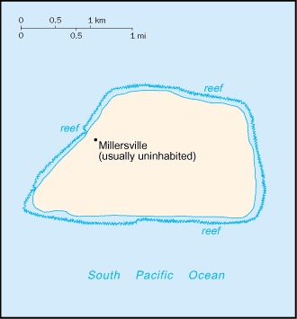
1935: The U.S. occupies and reclaims the island, Britain offering no objection. The Millersville settlement established on the western side of the island on March 26 (named for William T. Miller, superintendent of airways of the Bureau of Air Commerce) is occasionally used as a weather station until World War II.
February 1942: The island is evacuated by the Coast Guard ship Roger B. Taney in anticipation of a possible Japanese attack. All buildings are burned to the ground.
1957: The island is reoccupied during the International Geophysical Year by scientists who leave in 1958.
June 27, 1974: The island becomes a National Wildlife Refuge, with administrative responsibility transferred from the U.S. Department of the Interior's Office of Territorial Affairs to its Fish and Wildlife Service.
1983: Feral cats, which were a problem for some time, are eradicated.
September 2013: Kiribati and the U.S. sign a maritime boundary treaty formalizing the boundary between Baker and Jarvis Islands, Kingman Reef, and Palmyra Atoll and Kiribati's Line and Phoenix Islands.
2016: Scientists document the death of 98% of coral around Jarvis Island as a result of raised ocean temperatures following the 2015/16 El Niño weather phenomenon. There is, however, some recovery in the massive Porites colonies by early 2017.
Johnston Atoll
1796: The atoll is first encountered when the American brig Sally runs aground on a nearby reef. Captain Joseph Pierpont gives the earliest recorded account and accurate position of the two islands.
Dec. 14, 1807: The islands are sighted by Captain Charles Johnston of the frigate HMS Cornwallis, from whom they take the name.
March 19, 1858: The atoll is claimed for the U.S. by the captain of the schooner Palestine, which was chartered by two Americans, William Parker and R.F. Ryan, specifically to find Johnston and Sand islands and, if guano were discovered, to claim them under the Guano Islands Act. The presence of guano being confirmed, a flag is raised and signs are erected stating that the entire area is claimed for the United States and for the owners and charterers of the schooner.
June 14, 1858: Samuel Allen, sailing on the Kalama under the Hawaiian flag and representing the Kingdom of Hawaii, tears down the U.S. flag and signs on Johnston and raises the Hawaiian flag. On July 27 the atoll is declared part of the domain of King Kamehameha IV. The two islets are named Kalama Island and Cornwallis Island. However, several months later, the king revokes the lease on guano he granted to Allen when he learns that the atoll had been claimed previously by the United States.
Dec. 9, 1859: The Pacific Guano Co. receives the official certificate from the secretary of state stating that they have entered sufficient bonds to claim Johnston under the Guano Islands Act. Throughout their time on Johnston, the guano company harvests and ships guano until the highest grades are depleted and the island is abandoned in the late 1880s.
July 19, 1892: Captain Eustace Rooke of the Champion lands at the uninhabited atoll and leaves an annexation notice claiming it for Great Britain, which is planning a trans-Pacific cable. He observes four old huts from the guano companies and wreckage from the whaling bark Jacob A. Howland (which struck the reef on Dec. 26, 1889). In September it is reported that, the guano beds having been exhausted and the American firm having left the territory, State Department officials say the United States has no further interest in the island and has no right to interfere with Great Britain if she finds it of any use to her. An agent for the Pacific Islands Guano Co. claims that they did not abandon the islands and plan to resume work, but this does not apparently come to pass. The Hawaiian government protests British annexation of the atoll, and Britain later recognizes Hawaiian sovereignty based on the annexation by the Kalama in 1858, and apparently decides to run its cable through Tabuaeran (modern Kiribati).
1898: Johnston is annexed by the U.S. along with Hawaii.
Sept. 11, 1909: The Territory of Hawaii leases Johnston to a private citizen, Max Schlemmer, for 15 years under a set of stipulations, including the annual planting of coconut trees.
Aug. 8, 1917: Edward M. May reports to the commissioner of public lands that during his visit on the islands in 1914, they were uninhabited with no sign of coconut trees.
Aug. 8, 1918: After unsuccessful attempts to contact Schlemmer and reassert lease agreements, the commissioner assigns the lease to C.K. Ai and Co. A few men from the company are then sent to Johnston to begin fishing operations but only last one day on the island before they mutiny and return to Honolulu.
July 1923: The island is first mapped during a visit by the USS Whippoorwill and the USS Tanager for scientific research. A biological survey is conducted by the U.S. Department of Agriculture and the Bernice Pauahi Bishop Museum of Honolulu.
June 29, 1926: Executive Order 4467 designates Johnston Island and Sand Island a bird refuge, to be known as the Johnston Island Reservation.
Dec. 29, 1934: Executive Order 6935 transfers control to the U.S. Navy. The island remains under the additional jurisdiction of the Department of Agriculture for purposes of serving as a bird refuge.
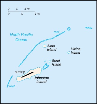
Feb. 14, 1941: In World War II, the airspace above and the waters within the 3-mile marine boundaries of Johnston and Sand islands are designated a Naval Defensive Sea Area and Airspace Reservation (Executive Order 8692). During the course of the war, the islands are developed as a military airbase and also serve as a submarine refuelling base. As use of the atoll increases, so does the land area; the military dredges coral from the lagoon to increase the length of the runways.
July 1, 1948: The U.S. Air Force assumes control.
1958-63: The site is used for high-altitude nuclear tests.
1963-64: Johnston Island and Sand Island are further expanded by coral dredging; additionally, two man-made islands are created, North Island (Akau) and East Island (Hikina), increasing the total land mass to 2.6 sq km. At this time the decision is made to refer to the area collectively as Johnston Atoll.
1964-73: The Air Force is an active presence on the atoll.
February-April 1965: The atoll is used for testing of biological weapons (Operation Shady Grove).
1971: The first chemical weapons arrive on Johnston Island from Okinawa.
1973: The Air Force agrees with the Defense Nuclear Agency that the latter will assume operational control of the atoll.
Mid-1970s: Surplus Agent Orange defoliant from the Vietnam War is stored on Johnston Island.
1985: Construction of a chemical weapons disposal facility begins. The Johnston Atoll Chemical Agent Disposal System (JACADS) is fully operational by 1990.
1989: The U.S. government agrees to remove artillery shells containing more than 400 metric tons of nerve gas from West Germany, and destroy them on Johnston Island.
Late 1991: Following expressions of protest to the U.S. government by the nations of the South Pacific Forum and many environmental groups, a team of scientists visits the chemical disposal facility to monitor the safety and environmental effect of its activities.
May 1996: It is reported that all nerve gases stored on the atoll have been destroyed. However, 1,000 tons of chemical agents remain contained in landmines, bombs, and missiles at the site.
December 2000: It is announced that the remaining stock of chemical weapons has been destroyed (the original deadline for the destruction of 40,000 weapons stored on the island was August 1995).
September 2001: Population decreases significantly when the U.S. Army Chemical Activity Pacific (USACAP) departs. In previous years there was an average of 1,100 U.S. military and civilian contractor personnel present.
June 2004: The closure and decontamination of the facility being completed, all military personnel leave and control of the atoll is transferred to the U.S. Fish and Wildlife Service.
March 2005: The U.S. Department of Defense announces the termination of the Air Force mission on Johnston Atoll. A facility capable of performing atmospheric tests of nuclear weapons remains operational.
July 2006: Johnston Island (only) is listed for sale by the Government Services Association.
Kingman Reef
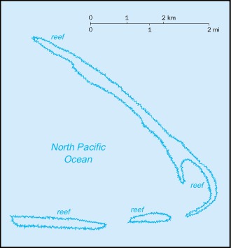
There are no terrestrial plants on the reef, which is frequently awash, but it does support abundant and diverse marine fauna and flora.
June 14, 1798: The reef is discovered by Captain Edmund Fanning of the American whaler Betsey. He describes it as "a coral reef or shoal, in the form of a crescent, about six leagues in extent from north to south; under its lee, and within the compass of the crescent, there appeared to be white and shoal water."
Jan. 21, 1853: The English ship Caldew, Captain William Joseph Snow, runs aground on a reef in the area which becomes known as Caldew Reef.
Nov. 29, 1853: The reef is rediscovered by Captain W.E. Kingman of the American ship Shooting Star, who says it was near the spot assigned to "Danger rock" on some charts. It ultimately takes the name from Kingman.
1859: The captain of the ship Alice Thorndike visits and reports the reef, which is thereafter known in some accounts by the name of the ship or simply as Thorndike Reef or Shoal.
1860: The reef is claimed by the American Guano Company, although there is no evidence that guano has existed there.
1862: Captain E.G. Crane reports the reef aboard the schooner Maria, and it is sometimes recorded as Maria or Crane Shoal.
June 22, 1874: The British steamship Tartar, commanded by J.S. Ferries, strikes the reef and spends two days run aground before landing safely in Honolulu on June 28.
April 16, 1888: The British iron barque Henry James, Captain Ralph Lattimore, wrecks on Kingman Reef. All 30 passengers and crew members remain at the small boats until morning and reach Palmyra Atoll in the evening (see Palmyra Atoll, below).
1897: The entire reef area is surveyed by HMS Penguin, commanded by Captain Arthur M. Field, and is considered identical to alternative names and points reported within the vicinity. Such names are subsequently removed from charts, including Caldew Reef and Maria Shoal.
May 10, 1922: Lorrin A. Thurston hoists the American flag over Kingman Reef, claiming it on behalf of the Palmyra Copra Company for use as a fishing base.
1926: The Navy ship USS Whippoorwill surveys Kingman Reef.
1933: The U.S. State Department concludes, in a study of islands claimed under the Guano Islands Act, that claims made under the act to Kingman Reef are not valid. However, an American had initially discovered it and no other nation claims it.
Dec. 29, 1934: Pres. Franklin D. Roosevelt places the reef under the control of the Navy, formally asserting American rights to it.
1937: Pan American Airways, pioneering the new airmail service with flying-boats between Hawaii and New Zealand, uses the sheltered lagoon as a half-way station between Honolulu, Hawaii, and Pago Pago, American Samoa. The route is abandoned after a flying-boat was lost off Pago Pago in January 1938.
1941: Kingman is included in a naval defensive area established by President Roosevelt.
1950: Congress enacts a law making Kingman Reef, along with several other insular areas, subject to the jurisdiction of the U.S. District Court in Honolulu for purposes of any criminal or civil cases that might arise there.
Sept. 1, 2000: The Department of the Interior accepts restoration of its administrative jurisdiction over Kingman Reef from the Department of the Navy.
Jan. 18, 2001: Executive Order 3223 is signed establishing Kingman Reef National Wildlife Refuge, including the surrounding waters out to the 12-nautical-mile territorial sea limit, to be administered by the director of the U.S. Fish and Wildlife Service.
September 2013: Kiribati and the U.S. sign a maritime boundary treaty formalizing the boundary between Baker and Jarvis Islands, Kingman Reef, and Palmyra Atoll and Kiribati's Line and Phoenix Islands.
Midway Islands
July 1859: U.S. captain N.C. Brooks of the Hawaiian barque Gambia discovers the islands, which are originally named Middle Brook Islands. The name becomes Midway later in the 19th century and reflects the islands' position in the North Pacific Ocean roughly equidistant between North America and Asia.
Aug. 28, 1867: Captain William Reynolds of the USS Lackawanna takes formal possession of the islands for the U.S.
1869: Congress appropriates $50,000 for making Midway into a naval station and for enlarging the channel through the reef into the lagoon.
Jan. 20, 1903: Pres. Theodore Roosevelt issues an executive order placing Midway under the jurisdiction and control of the U.S. Navy. The laying of the trans-Pacific cable, which passes through the islands, brings the first residents.
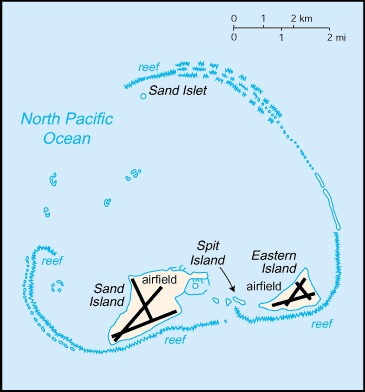
1935-47: Midway is used as a refuelling stop for trans-Pacific flights. A hostel is built on Sand Island for overnighting plane passengers.
1940: Construction of a naval air station begins. The station is commissioned on Aug. 1, 1941.
Feb. 14, 1941: By Executive Order 8682, Midway is designated a Naval Defense Sea Area and Airspace Reservation.
Dec. 7, 1941: On the same day Pearl Harbor is bombed, Midway is attacked by a Japanese raiding party of four ships.
June 3-5, 1942: The U.S. naval victory over a Japanese fleet off Midway is one of the turning points of World War II.
Mid-1943: Population has reached 5,000.
Sept. 4, 1962: Administrative control by the Department of the Navy is confirmed by Executive Order 11048.
1970s and '80s: The Navy begins the phase-out of operations on the atoll.
1993: The naval station is closed. Environmental impact studies subsequently indicate widespread contamination from a variety of man-made materials to the environment and the native wildlife.
Oct. 31, 1996: Through a presidential executive order, the jurisdiction and control of the atoll is transferred from the U.S. Navy to the Fish and Wildlife Service of the Department of the Interior as part of the National Wildlife Refuge System.
1996-2002 and 2008-12: The refuge is open to the public.
June 1997: Cleanup by the Navy is completed.
2000: The lands and waters of the Midway National Wildlife Refuge are also designated as the Battle of Midway National Monument; Henderson Airfield on Sand Island continues to serve as an emergency landing field for military and civilian aircraft transiting the Pacific Ocean.
March 2011: It is reported that thousands of seabirds, including albatrosses and other endangered species, have been killed by the tsunami that followed the powerful earthquake off the east coast of Japan.
April 2013: A study of Midway Atoll by the U.S. Geological Survey is concluded, indicating that rising sea levels resulting from climate change could inundate low-lying Pacific islands far earlier than previously estimated, predicting, for example, that more than 90% of Eastern Island would be submerged if sea levels rose by 2 m.
July 2014: Approximately 40 people make up the staff of the U.S. Fish and Wildlife Service and their service contractors living at the atoll.
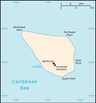
Navassa Island
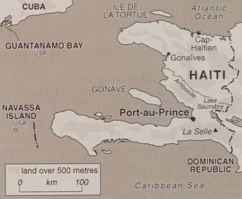
1504: The flat island is named "Navaza" by some of Christopher Columbus' sailors; the name derives from the Spanish term nava meaning "flat land, plain, or field." They declare the island worthless when they visit briefly, finding no food or water but an abundance of scorpions, poisonous plants, and razor-sharp rocks that slice through boots and demolish boats.
1801: Haiti begins to claim the island. It has also since been claimed by Colombia, Cuba, Honduras, Jamaica, and Mexico.
1803: The island is surveyed by Francis Owen, Royal Navy, who describes it as "a flat level rock, apparently of volcanic origin; it is covered with small shrubs, and is about 300 feet [91 m] in height."
October 1857: The uninhabited island is claimed for the U.S. by Peter Duncan under the Guano Islands Act of 1856. By 1866 the population consists of 30 white men, officers, and mechanics and 180 black labourers.
1889: The island's actual operation passes to the Navassa Phosphate Company.
Sept. 14, 1889: Henry Jones, a black labourer employed by the Navassa Phosphate Company, takes part in a riot against the cruelty of the white supervisors. Five whites are killed. Jones and two others are tried and convicted in federal court in Baltimore for murder and sentenced to death. This leads to a Supreme Court case in which Jones challenges the constitutionality of the Guano Act, the authority of the U.S. government over Navassa, and the jurisdiction of the American court. His arguments are rejected in 1890, but Pres. Benjamin Harrison commutes the death sentences to life imprisonment.
1898: Mining operations are terminated due to the Spanish-American War.
Feb. 4, 1916: By proclamation of Pres. Woodrow Wilson, the island is declared to be under the sole and exclusive jurisdiction of the United States.
1917: Navassa Island Light, a 46-m-tall lighthouse on the southern side of the island, is built to safeguard the increased number of ships passing the area following the opening of the Panama Canal.
September 1996: The Coast Guard ceases operations and maintenance of the lighthouse after determining that a light on Navassa was no longer needed in view of advances in electronic navigation.
Jan. 16, 1997: Administration of Navassa Island is transferred to the Department of the Interior, Office of Insular Affairs.
March 27, 1997: The Department of the Interior denies a claim for a permit to mine guano on Navassa presented by an American salvager to the Department of State under the Guano Islands Act. It is argued that the act applies only to islands which at the time of the claim are not "appertaining to" the United States and that Navassa is accordingly unavailable to be claimed.
August 1998: Researchers announce the results of the first scientific expedition to the island in more than a century, describing it as a "unique preserve of Caribbean biodiversity," with as many as 250 species believed to be entirely new to science, as well as pristine coral reefs. Visits to the island and its surrounding waters are subsequently prohibited, pending further assessment of the island's environment.
Sept. 2, 1999: The island becomes a National Wildlife Refuge. Annual scientific expeditions have continued.
Dec. 3, 1999: Administration of Navassa is transferred from the Office of Insular Affairs to the Fish and Wildlife Service.
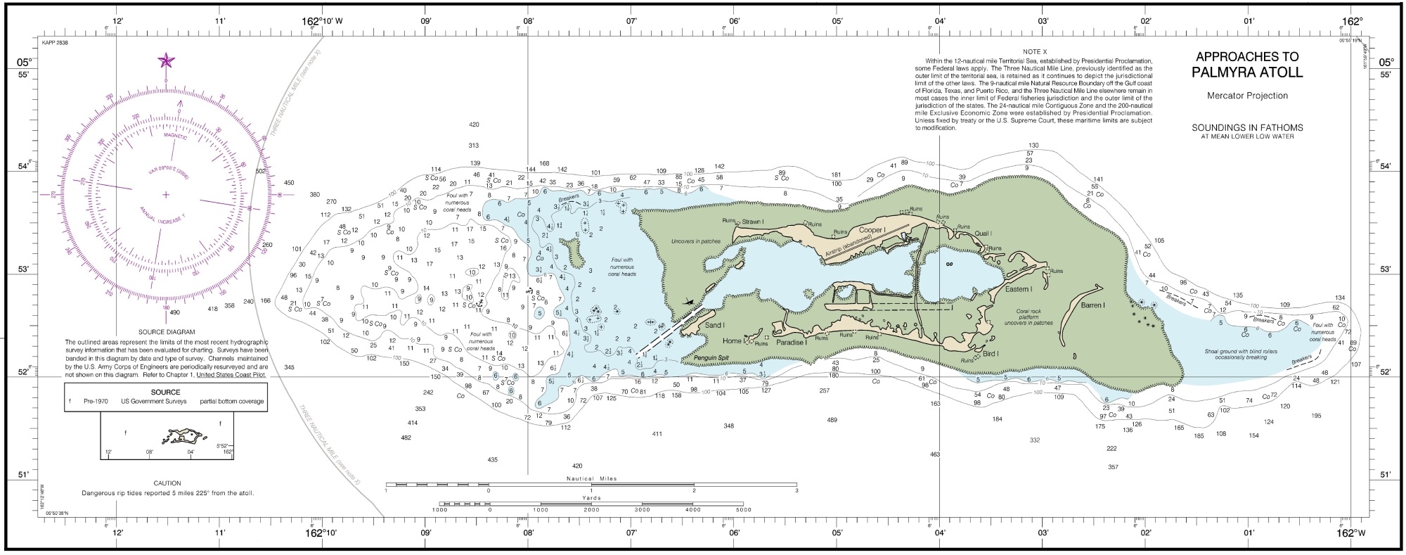
Palmyra Atoll
Nov. 7, 1802: Captain Cornelius Sowle of the USS Palmyra discovers the atoll, which gets named for the ship.
Oct. 20, 1859: Gerrit P. Judd takes possession of Palmyra for the United States as an agent of the American Guano Company. However, due to local environmental conditions, the availability of commercial guano is highly unlikely and no claim is ever formally filed nor is there evidence of guano companies ever occupying or operating at Palmyra.
April 15, 1862: Captain Zenas Bent claims the atoll for the Kingdom of Hawaii in accordance with a royal commission issued to him by King Kamehameha IV. On June 18 Hawaii issues a proclamation announcing the annexation.
Dec. 14-27, 1873: The atoll is surveyed by surgeon William H. Jones of the USS Portsmouth, Commander Joseph S. Skerrett, who creates the first standard chart of the area. They encounter an American businessman, Clayton L. Strawn, who is living on the island curing copra.
1885: Rights to Palmyra are sold to the Pacific Navigation Company, which pays taxes to Hawaii for Palmyra from 1885 to 1888. During that time, the company contracts a man named Dillon and his wife to live on the island for a year to plant coconuts, cut firewood, and seek commercial endeavours for fish and shells. On Oct. 25, 1886, Dillon reports that the coconut trees on the island include 2,100 full bearing large trees, 1,000 full bearing small trees, 500 old trees not bearing, and 6,000 young trees not bearing.
April 17, 1888: The 30 passengers and crew members from the Henry James, wrecked on Kingman Reef, arrive at Palmyra. Although they find the islands uninhabited, they observe several huts and firewood that is cut and piled. With few provisions left by April 21, it is decided that the mate, boatswain, and several seamen will head to Samoa in one of the boats. They arrive in Apia after 19 days and charter the schooner Vindex to pick up the stranded party. Meanwhile, aboard the steamship Mariposa, Captain H.M. Hayward learned of the wreck from Lieutenant Cressap, of the USS Mohican in Apia. Captain Hayward rescues the party on May 29, and everyone makes it to Honolulu in good health. Captain Ralph Lattimore reports that during their six weeks on
Palmyra, all hands procured fresh water and subsisted on coconuts, fish, eels, birds, land-crabs, and peppergrass.
May 28, 1889: Commander Nichols, of HMS Cormorant, annexes Palmyra for Great Britain during its plans to construct a trans-Pacific cable.
July 16, 1897: The Hawaiian Star publishes a report from Captain Rosehill, of the schooner Norma, regarding British claims to the atoll. He reports that during his brief landing on the island, he found a weathered flagpole with a proclamation declaring the islands under possession of Great Britain, along with scattered remnants of clothing and items marked "HMS Penguin." Following this report, Palmyra owners follow up to successfully dispute British claim through rights secured from the Pacific Navigation Company and the Hawaiian government via the 1862 annexation.
Dec. 16, 1898: Pres. William McKinley's message to Congress especially mentions Palmyra among the Hawaiian Islands that have been annexed by the U.S.
1911: The Pacific Navigation Company's rights are conveyed to Judge Henry E. Cooper.
February 1912: Knowing that Great Britain has lingering interests in Palmyra, the U.S. takes formal possession of the atoll through the USS West Virginia. Four months later, the attorney general of Hawaii having disclaimed any territorial interest in the land, the Land Court of Hawaii confirms Cooper's title as owner of Palmyra.
July 1913: Cooper, Joseph F. Rock, and Dr. C.M. Cooke, Jr., travel to Palmyra aboard the Luka and survey the atoll. Along with his comprehensive botanical surveys and many photographs, Rock provides detailed descriptions of Palmyra Island as well as Bird, Eastern, Home, Holei, and Cooper islets. Among his observations are references to Japanese inhabitants: "On Home Islet were signs of previous habitation. We found a wooden shack, covered with corrugated iron, full of wood and boxes with Japanese characters written on them..."
1920-21: The island is leased to Col. William Meng, his wife Idell Meng, and Edwin Benner, Jr., who live on Palmyra to investigate commercial copra production and fishing possibilities. At that time there are about 25,000 bearing coconut trees on the atoll.
Aug. 19, 1922: Cooper sells parts of the atoll for $15,000 to Leslie and Ellen Fullard-Leo, who establish the Palmyra Copra Company. Over the next few years, the Fullard-Leos acquire all of the atoll, except for the two islets retained by Cooper's heirs (after Cooper's death in 1929).
1938: The Navy begins to seek to lease Palmyra from the Fullard-Leos, but negotiations are suspended when the attorney general in 1939 concludes that Palmyra is U.S. public land and that the Fullard-Leo claim is invalid. Congress then authorizes the construction of naval aviation facilities on Palmyra. The Navy subsequently occupies Palmyra and builds a runway and several buildings.
1940-45: Major shoreline changes occur when military construction creates a dredged channel into the lagoon, enlarges several islands, joins most islands around the lagoon system into a continuous roadway, constructs a causeway separating two lagoons, and creates several new islands. Overall, land area approximately doubles and land volume approximately trebles during this period. A total of 52 islands is made into 39. The U.S. Navy has 6,000 men on the island during World War II.
1941: Palmyra is included in the naval defensive area established to protect Hawaii.
Dec. 24, 1941: A Japanese attack causes only minor damage.
May 1947: After a protracted legal battle, the Supreme Court rules 5-4 that property rights to Palmyra belong to Leslie Fullard-Leo and his family, and the U.S. government cannot own it, although Palmyra is under U.S. jurisdiction. The Fullard-Leos wanted to colonize it as a place of "peace and graceful living." (Australian-born Leslie Fullard-Leo dies in Honolulu, aged 83, on Feb. 20, 1950.)
1959: The Hawaii Statehood Act specifically excludes Palmyra Atoll from the State of Hawaii.
July 12, 1960: Section 48 of the Hawaii Omnibus Act permits the president to vest authority for the civil administration of Palmyra in such person as he may choose.
Oct. 10, 1961: Pres. John F. Kennedy issues an executive order vesting administration of Palmyra to the secretary of the interior.
1962: A Californian firm tries to promote Palmyra as a resort and tourist area, but it does not eventuate.
1974: The atoll becomes briefly famous when a yachting couple is murdered there, lawyer and author Vincent Bugliosi publishes And the Sea Will Tell, and a television movie is made.
Aug. 21, 1979: The family owners of Palmyra say that the island is not for sale at "any price" as a nuclear waste dump. Reports from Washington, D.C., indicated that the government wanted to use Palmyra as a dumping ground for nuclear wastes. The U.S. government reportedly had set $20 million as a "fair price." "We do not feel we are being unpatriotic or un-American," says Ainsley Fullard-Leo, who along with his two brothers owns the island. "We think Palmyra is the wrong place for storing nuclear wastes, and we don't want to have it used for this purpose." Administration officials confirmed that a nuclear survey team had secretly visited Palmyra earlier in 1979 and concluded that it would be an excellent storage site for nuclear waste, particularly the spent rods from Asian atomic reactors. Fullard-Leo says his family would publicly oppose the government if it attempted to condemn Palmyra and through the courts force his family to sell.
Mid-1996: It is announced that the owners (the Fullard-Leo family in Hawaii) are to sell the atoll to a U.S. company, which, it is believed, plans to establish a nuclear waste storage facility in the territory. The government of neighbouring Kiribati expresses alarm at the proposal, and reiterates its intention to seek the reinclusion of the atoll within its own national boundaries. However, in June one of the Hawaiian representatives to the U.S. Congress proposes legislation to prevent the establishment of such a facility, and a U.S. government official subsequently announces that the atoll will almost certainly not be used for that purpose.
May 4, 2000: The Nature Conservancy (TNC), a private conservation group, announces plans to purchase and preserve Palmyra Atoll. TNC says it will create a nature preserve on the atoll, which is home to the rare coconut crab and a large population of red-footed booby birds, and is one of the few nesting habitats for migratory birds within the surrounding 1.2-million-sq-km area. TNC will purchase the atoll from the Fullard-Leo family at a price not disclosed, but reportedly far less than the $47 million the family originally sought. The purchase occurs in December.
Jan. 18, 2001: The lagoons and surrounding waters within the 12-nautical-mile U.S. territorial seas, which have been transferred to the U.S. Fish and Wildlife Service, are designated a National Wildlife Refuge. This is extended later this year by the purchase of about 2.75 sq km of emergent land from TNC by the Fish and Wildlife Service.
November 2005: An international team of scientists joins with TNC to establish a scientific research station at Palmyra with accommodations for up to 20 researchers.
June 2012: The U.S. Fish and Wildlife Service and TNC successfully conclude a project to eradicate non-native black rats from Palmyra Atoll, as part of a wider effort to restore the atoll's ecological balance.
September 2013: Kiribati and the U.S. sign a maritime boundary treaty formalizing the boundary between Baker and Jarvis Islands, Kingman Reef, and Palmyra Atoll and Kiribati's Line and Phoenix Islands.